Welcome to ISLM!
The Survey Training School was established by the British Government in 1944 at Katabi sub –county in the then Mpigi District and currently in Wakiso District for specialized training of technicians to generate National Maps. The history of training technicians in the Engineering and Surveying in Uganda dates back to 1922 when a pioneering group of students were admitted to Makerere Technical College.
Explore our programs

National Certificate in Land Management and Geomatics
The National Certificate in Land Management and Geomatics (NCLMG) programme is designed to serve as a bridging course between Ordinary level graduates and the Diploma Level. This industry-recognised programme is built on a competence-based approach and is delivered by industry experts in their fields. It also serves a stepping stone for other professionals from other fields with an interest in the field of land management and geomatics.
Course overview:
This certificate programme serves as a bridging pathway for secondary school students, equipping them with the necessary knowledge and skills to embark on advanced studies in surveying, land management, valuation, cartography, or physical planning. It lays a robust foundation by introducing students to critical aspects of these fields, integrating both practical skills and theoretical understanding. The aim is to prepare students for the rigors of a National Diploma in these specialized areas, ensuring a smooth transition from secondary education to higher level studies, and ultimately, fostering success in their chosen field.
Throughout the program, students will explore various fields of land management and geomatics, with the aim of identifying and pursuing the one that aligns with their interests and qualifications. This is further enhanced by the different practical projects carried out at the end of each year.
Course Content.
The curriculum for the programme is approved by National Curriculum Development Centre and aligns with the National Development Plan III (2020-2025), TVET Policy (2019), BTVET Strategic Plan. The curriculum is competence-based and integrates practical skills with theoretical understanding to lay a robust foundation. The module-based arrangement of the curriculum is aimed at enhancing ease of delivery and learning, facilitating enriched learning experiences and enabling a smooth transition to more specialized studies, thereby fostering educational excellence in the chosen fields.
Entry Requirements:
A candidate shall be eligible for admission to the National Certificate in Land Management and Geomatics program upon attaining a Uganda Certificate of Education (UCE) with at least five passes, including a credit in Mathematics and a credit in English at the Ordinary Level.
Programme Duration
The National Certificate in Land Management and Geomatics shall be completed within a minimum of two academic years and a maximum of five years. Each academic year comprises two semesters, each lasting 17 weeks, with 15 weeks for training and continuous assessment and 2 weeks for final examinations.
Award
A student who successfully completes all the modules in the program shall be awarded a classified National Certificate in Land Management and Geomatics by the examining body.

National Diploma in Land Management and Valuation
At least a principle pass in Mathematics or Economics and two subsidiary passes in Physics, Geography, Chemistry, or at least a CGPA of 3.00 in CLMG

National Diploma in Physical Planning
Mathematics or Physics, Geography and two subsidiary passes in Economics, Entrepreneurship, Fine Art, Chemistry, Geography, T.D at UACE or at least a Second Class Lower Division of CLMG

National Diploma in Cartography and Geoinformatics
At least a principle pass in Mathematics or Physics and two subsidiary passes in any of Economics, Chemistry, T.D, Geography or at least a CGPA of 3.0 in CLMG

National Diploma in Land Surveying
Minimum Requirements:
At least a principle pass in Mathematics or Physics and two subsidiary passes in either Economics, Chemistry, T.D, or Fine Arts, Entrepreneurship and at least a Second Class Lower Division of CLMG.

Geographical Information System(GIS)
Certificate in GIS is for a period of 2 weeks from 5:00pm-9:00pm
Fees structure
Admission fee = 50,000/=
Tuition= 750,000/=
Field Work = 300,000/=
International Students USD 500
NEWS UPDATE
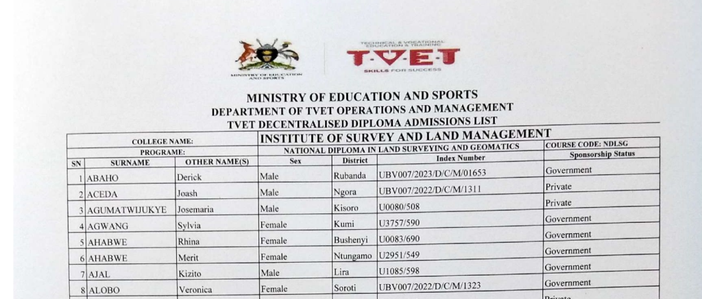
Admission Lists 2025-2026
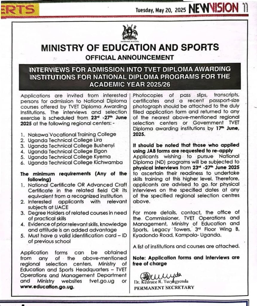
Interviews For Admission Into TVET Diploma Awarding Institutions
Short Courses – Announcement
Official Announcement

Fees Structure September 2025

Circular 04-2025
OUR STANDING
OUR EVENTS
DATE:
2025-02-15
TIME:
09:00
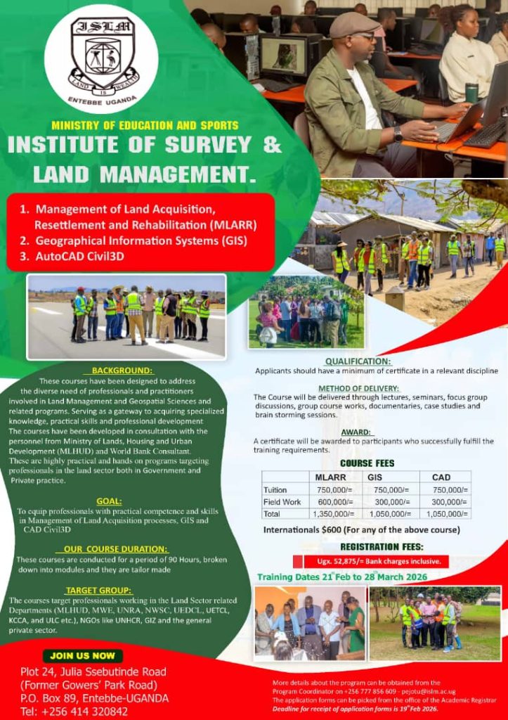
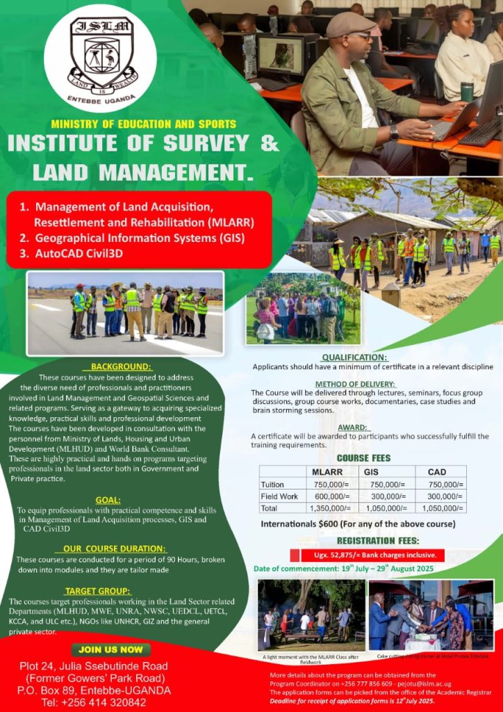
Training for Geographical Information Systems (GIS), Auto CAD / civil 3D
TRAINING DATES
15th February, 2025 – 28th March, 2025
AWARD
A Certificate of Training will be awarded to participants
upon successful fulfillment of the training requirements.
More details about the program can be obtained from the Program Coordinator on +256 777 856 609 – pejotu@islm.ac.ug. The applications forms can be picked from the office of the Academic Registrar.
Deadline for receipt of application forms is 15th February, 2025.
DATE:
2025-02-15
TIME:
09:00
Training for Management of Land Acquisition, Resettlement and Rehabilitation
TRAINING DATES
15th February, 2025 – 28th March, 2025
AWARD
A Certificate of Training will be awarded to participants
upon successful fulfillment of the training requirements.
More details about the program can be obtained from the Program Coordinator on +256 777 856 609 – pejotu@islm.ac.ug. The applications forms can be picked from the office of the Academic Registrar.
Deadline for receipt of application forms is 15th February, 2025.
DATE:
2024-11-30
TIME:
10:00
School clinic opening
The opening of our new school clinic marks a significant step in promoting the health and well-being of our students and staff. This facility is designed to provide accessible medical care, first aid, and wellness support, ensuring a safe and nurturing environment for everyone.
With its modern equipment and dedicated healthcare professionals, the clinic underscores our commitment to fostering a community where physical and mental health are prioritized alongside academic excellence
DATE:
2024-11-22
TIME:
11:00
Alumni meet and greet
We are excited to invite all former students to our Alumni Meet and Greet, a special event to reconnect, reminisce, and celebrate the bond we share as members of our school community.
This event offers a fantastic opportunity for alumni to catch up with old friends, share memories, and network with fellow graduates across different years. It’s also a chance to learn about the school’s latest developments, initiatives, and plans for the future.
The program includes a welcome address by the school leadership, an alumni sharing session, and interactive activities designed to rekindle fond memories. Attendees will enjoy a guided tour of the campus to witness how the school has grown and evolved over the years.
Whether you’re looking to reconnect with former classmates, share your professional journey, or mentor current students, this Meet and Greet is the perfect occasion. It’s also a wonderful platform to build new connections within our vibrant alumni network.
Light refreshments will be served, and there will be entertainment to make the day enjoyable for everyone. Come with your stories, laughter, and school spirit as we celebrate the enduring legacy of our school community.
We can’t wait to welcome you back and hear how far you’ve come since your time with us. Mark your calendars and join us for an unforgettable reunion at the Alumni Meet and Greet!
DATE:
2024-11-14
TIME:
07:35
Connect & Celebrate With Us
The history of training technicians in Engineering and Surveying in Uganda dates back to 1922 when a pioneering group of students were admitted to Makerere Technical College.
Over time the Survey technician’s course was transferred to Nakawa Vocational School and then to Katabi Entebbe in 1944. From 1996 onwards, the Government of Uganda has been carrying out the Public Service Reform Program whose objective is to improve efficiency and effectiveness within the Public Service.
One of the Key components of this reform is the restructuring and rationalization of all Government functions while taking Cognizance of the existing legislation and emerging Government policy. In the same spirit, Government came up with a policy that transferred all teaching tertiary institutions from their respective sector Ministries to the Ministry of Education and Sports.
The rationale was to ensure effective coordination and consistency as the Government no longer trains personnel for public service only, but rather for the wider market which is both local and international.
The transfer process involved reviewing the operations and structures of the transferred institutions. To that effect, it was decided to merge the Survey Training School-STS and the Physical Planning School into the Institute of Survey and Land Management (ISLM).
OUR PARTNERS